

MapProjector - Create and Present Maps app for iPhone and iPad
Developer: EpIPhone Coders Guild
First release : 26 Apr 2010
App size: 22.73 Mb
Present live maps and satellite imagery from any iPad to a TV or projector! MapProjector lets you create unlimited maps with labeled landmarks and measurements, and present them on the big screen.
"A great update ... Thank you! ***** (5 stars) by PortaDisk
The author listened to my "feature request" ... and responded with a stylish and very effective update. This App is really useful, and great value."
Live updates let you zoom and scroll your maps and add measurements, photos, pins or symbols to mark paths or points of interest with a title and caption, all while presenting your maps to a larger audience. Quickly switch the live display to a background of your choice, and restart it instantly. No need to disconnect if you want to prepare in private.
And you dont need to connect to an external display to use MapProjector to build and manage maps and landmarks. You can save snapshots, email links to maps and landmark markers, or use your free Google account to create cloud-based maps using Googles powerful Fusion Tables service, to edit from any browser and share with whomever you choose. Or export to a spreadsheet using CSV export to iTunes or Dropbox*.
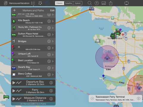
To use MapProjector scroll the map by dragging, pinch to zoom. Press and hold on a spot to drop a marker there. Define a range for any marker to display a circle on the map showing the locations within that distance.
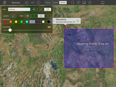
Switch Path or Area mode to add a marker for an open or closed path. You can add any number of paths and move markers between them. And any path can display its title, total length/area, and the lengths of its segments.
Download Map Projector today, youll have the world at your fingertips.
Features:
- Create an unlimited number of maps with unlimited landmarks
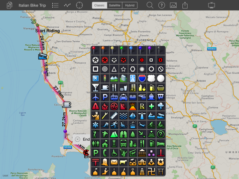
- Landmarks - Place markers on the map with symbols and labels
- Ranges - Add a transparent colored circle to any marker showing all the locations within an exact range of the marker
- Paths - Press and hold in path mode to make a path with title, color and optional distance labels
- Areas - Make a closed, filled path that calculates and displays the area enclosed
- Photos - Import photos from your Photo Album using their own locations to put them on the map.
- Email map as embedded links to Google Maps for your map and for each marker, no account required
- Export map with markers, symbols, ranges, areas, and paths to Google Fusion Tables account, where you can share, edit and process your maps further
- Display maps in Classic map mode, Satellite image mode, or Hybrid satellite image with markers mode
- Save hi-res snapshot of map to photo album
- Fast navigation with marker list, jump to any marker on the map with a tap
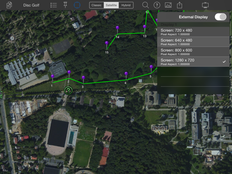
- Support external video display using Apple HDMI, Composite, Component or VGA video adaptor cables
- Full HD resolution maps on iPad2 or better with HDMI video adapter.
- HD 720p Wireless display on AppleTV using AirPlay (Turn On Mirroring in iPad first)
- AirPrint support - Print maps directly to supported printers
- Precision Puck - Easy yet highly accurate marker placement using offset crosshairs. No more wishing your fingers were transparent!
- Optional Current Location marker helps you find yourself, wherever you are
- Easy to use. MapProjector says what it does, does what it says
- Location Search - Find places using by just typing in a name or keyword. Choose from the results to place a marker automatically
- Built-in Help - MapProjector is easy to use, but a little help cant hurt
- Reverse Geocoding - MapProjector fills in the street address of a location for you when creating markers.
- Import Google Fusion Tables - Maps you upload to Googles cloud can be imported into MapProjector, allowing you to share maps with others or backup and restore your own.
- Jump to Fusion Table - One touch to view your newly uploaded Fusion Table in a browser.
- iTunes File Sharing Support - Backup, restore or share maps by directly copying files.